
|
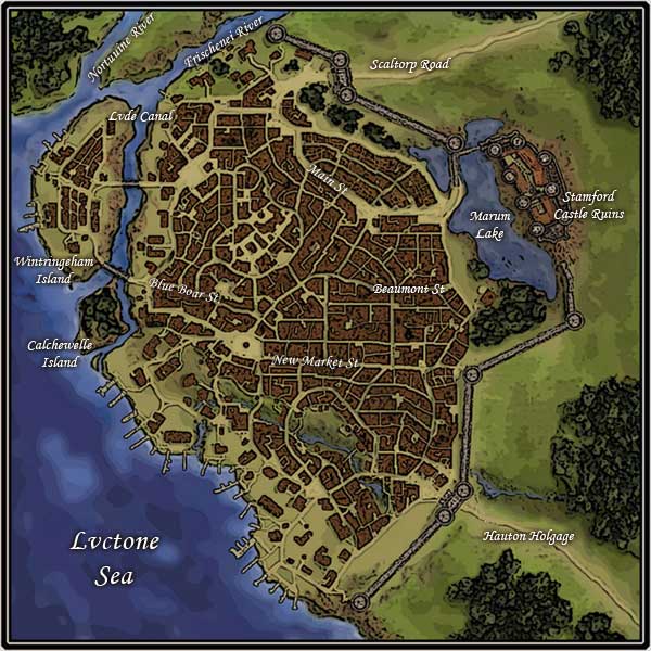
Cutting a jagged northern border along Aemaeth, the Frischenei River then spills lazily into both the Lvctone Sea and Canal. To the west of Aemaeth are two small islands. The Wintringeham isle connects to the mainland via two rope bridges; one to it's south and one almost at the center of the larger of the two islands. These rope bridges stretch over the eighty foot rocky drop below, and swing precariously in high winds. Their travel is not for the weak of heart. Calchewelle Island is only accessible by boat or ferry. Just beneath the island of Calchewelle, the many docks of port Aemaeth begin, stretching to almost the southern most border. East of the city is the Marum Lake, resting against the ruins of the once grand Stamford Castle. The castle fell victim to the horrible earthquake that shook the area, and did the outer wall protecting it. Some parts of the castle still stand, including one tower, but it is a dangerous place to explore, as what still remains is damaged severely. Much of the wall is also broken, in some places with wide opened gaps. To the far side of the ruined castle, spanning from north to south along the land locked side is a dense, verdant forest. Scaltorp Road beats a path through the foliage of the forest, being the main northeastern road leading to the fair city.
Hauton Holgage also meanders through the wooded expanse, giving a main road at the southeastern boarder of Aemaeth. |
 |
|
| Home |
| Rules | Medieval Setting of Aemaeth | | Modern Setting of Evernight | Frequently Asked Questions | | New to Role Play? Here are Some Suggestions and Advice | | Glossary of Commonly Used RP and Chat Terms | | Some Role Play Etiquette | | Our Chat Room | | Our Message Board | All literary works, images or other creations found here, as well as our website information © 2003-2009 by Golgotha RPG / Arcane RPG or by their respective creators. All rights reserved. |
